Colorado Unit 67 Hunting Information

Home » Hunting Informations » Colorado Units Hunting Information » Colorado Unit 67 Hunting Information

Overview of GMU 67 Hunting Facts

Located in Gunnison, Hinsdale and Saguache counties, Unit 67 in southwest Colorado provides the perfect setting for your big game hunt! The success rates are high with a strong deer and elk population. These factors mix for the ultimate hunting showdown. The terrain offers sweeping views of the landscape ideal for glassing big game from the high points. The Gunnison National Forest and La Garita Wilderness help create a scenic, isolated location for your hunting trip to Colorado unit 67. As a convenient hunters resource, there is a CPW Office, Forest Service Office and BLM Field Office all located in Gunnison at the northern point of the unit. For more Colorado Unit 3 hunting information, check out the Info for Cities Near Unit 67 section on the right.

Table of Contents

Unit 67 Species Hunting Info

INFO: Mule Deer Hunting in Colorado Unit 67
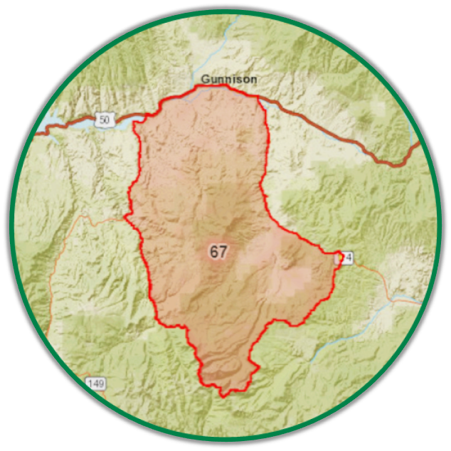
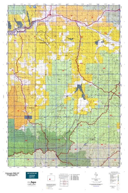
Unit 67 sits at an elevation that averages 10,000 feet, which can be a huge factor in determining your hunting location. Depending on the season you draw for, your hunting locations will be influenced differently with the weather, seasons, deer activity and of course, the rut. Mild winters have been experienced in this unit, so keep in mind that no two seasons are the same. Keep an eye on the weather patterns, season dates and the expected rut time frame of the year you are hunting. The warmer temperatures will keep the wildlife active in the higher altitudes. As the weather cools down, they will descend from the mountains into the lowlands. The area contains a vast network of creeks and streams that provide a water source for wildlife, adding another element to planning your mule deer hunt in Colorado unit 67. In addition to the highly regarded characteristics, unit 67 also carries a high success rate of buck tags drawn, sometimes as low as 2 points!

SUCCESS RATES for Mule Deer Hunting in Colorado Unit 67
5 Year Estimated Average for Deer
Archery 45%
Muzzle Loader 40%
2nd Rifle 65%
3rd Rifle 75%
4th Rifle 90%
Mule Deer TROPHY QUALITY for Unit 67 Colorado
Average Quality 150″ – 170″
Trophy Potential 190″+
Buck to Doe Ratio 40:100
Colorado Unit 67 Mule Deer Hunting FORUM Coming Soon!

INFO: Elk Hunting in Colorado Unit 67
The inclusion of La Garita Wilderness helps maintain this unit’s appeal to elk hunters. The elk can be found in the wilderness frequenting one of its numerous streams, taking cover in its coniferous forests or grazing on its multiple food sources. The elk will retreat into the harder to reach areas once the hunting pressure increases, so you must be willing to venture out past the roads and trails in order to find them. Elk tag ordinances are very straightforward in that all tags for all seasons are valid for hunting either sex and are only permitted in unit 67.

SUCCESS RATES for Elk Hunting in Colorado Unit 67
5 Year Estimated Average for Elk
Archery 30%
Muzzle Loader 20%
1st Rifle 22%
2nd Rifle 10%
3rd Rifle 20%
4th Rifle 15%
Elk TROPHY QUALITY for Unit 67 Colorado
Average Quality 280″ – 320″
Trophy Potential 320″+
Bull to Cow Ratio 23:100
Colorado Unit 67 Elk Hunting FORUM Coming Soon!

INFO: Antelope Hunting in Colorado Unit 3
Unit 67 maintains an overall success rate above 50%, which is encouraging if you are looking to hunt pronghorn in central Colorado. This is a draw-only unit so the sooner you get put in, the sooner you will be able to get started with your pronghorn hunting trip to unit 67 Colorado!

SUCCESS RATES for Antelope Hunting in Colorado Unit 3
5 Year Estimated Average for Antelope
Archery 30%
Muzzle Loader 80%
Rifle 90%
Antelope TROPHY QUALITY for Unit 3 Colorado
Average Quality 70″ – 80″
Trophy Potential 80″+
Buck to Doe Ratio 28:100
Colorado Unit 3 Antelope Hunting FORUM Coming Soon!

Available Hunts for Colorado Unit 67

Unit 67 Hunting Information Video

iconinfo.png

Info for Cities Near Unit 67

lay-of-the-land-icon-.gif

Colorado Unit 67 Topo Map

Total Acreage: 431,000 over 673 square miles

Total Public Land: 362,000 acres or 83%

Land Ownership Mix: 17% Private; 83% Public; USFS: 170,368 acres; USFS Wilderness: 26,624 acres; BLM: 178,752 acres; State: 8,960 acres; Other Govt. Owned: 1,408 acres

Species: Black Bear, Elk, Mule Deer, Moose, Pronghorn

Elevation Variances: 7,600 ft. to 14,014 ft.

Terrain Difficulty Overall: Mild to Moderate

Land Coverage/Vegetation: 27% evergreen forest, 21% grasslands, 32% shrub/scrub and 12% deciduous forest

Unit 67 Boundaries: (Gunnison, Hinsdale, Saguache County Colorado) bounded on North by US-South Highway 50; on East by Colorado 114 and North Pass; on East and South by Continental Divide; on West by Cochetopa Creek-Spring Creek Divide, Groundhog Park, Cathedral Creek, Spring Creek, Cebolla Creek and Colorado 149

map-icon.png

Lay of the Land in Unit 67

lay-of-the-land-icon-.gif

Terrain in GMU 67 CO

Throughout the unit is an assortment of terrains that all collaborate to bring hunters the best overall experience this unit can bring! The foothills are covered in various grasses and meadows surrounded by evergreen forest. The lower lying areas contain croplands and pasture, which serve as a winter forage location for wildlife. The southern portion of the unit contains the higher peaks of the San Juan Mountains, including a 14er summit, San Luis Peak. The ground texture ranges from rich soil to igneous rocklands accredited to the San Juan Volcanic Field. The overall elevation of the unit ranges from 7,400 – 14,000 feet, so be sure to prepare ahead of time for these altitudes. A good rule of thumb is to pre-acclimate to the region at least a couple of days prior to your hunting trip.
vegetation-icon.png

Vegetation in Unit 67 CO

The vegetation of Unit 67 is one factor that plays a role in the solid hunting reputation that this unit has to offer! The upper elevations contain the coniferous forests characterized by the alpines, spruces and firs that can withstand the cold winters known to Colorado. The middle elevations contain a mix of scrub oaks and Gambel’s oak brushwoods that provide wildlife cover and acorns to feed on. In addition to being a benefit to wildlife, these trees provide a benefit to hunters. When the leaves are lost on these oak trees, they assist hunters in glassing big game by giving them a more translucent glimpse into the thickets. The lower elevations provide the shrubbery of sage that is typical on the rolling hills, but also the multiple streams and rivers support their own group of vegetation known as riparian vegetation. The foliage most associated with this group are the cottonwoods and willows that line the river banks.
map-directions-icons.png

Access Points in GMU 67

The main highways that run through Unit 67 are SH-114, which runs SE and NW through the unit and Route 50, which winds along the northern boundary line of the unit. There are multiple BLM roads and trails throughout the unit and stay updated with the Motor Vehicle Use Map, to know which areas are permissive of motor vehicles and which are prohibited.