Colorado Unit 20 Hunting Information

Home » Hunting Informations » Colorado Units Hunting Information » Colorado Unit 20 Hunting Information

Overview of CO GMU 20 Hunting Facts

Colorado Unit 20 is located in the cross-section of 3 national wilderness territories. These include Comanche Peak Wilderness, Indian Peaks Wilderness, and Rocky Mountain National Park Wilderness, all of which have different sets of rules and regulations that should be reviewed by anyone hunting in this unit. The Rocky Mountain National Park strictly prohibits hunting. Comanche Peak Wilderness and Indian Peaks Wilderness permit hunting but rules and regulations should be observed. The eastern side of Unit 20 is characteristic of grasslands with a drier climate covered in shrubbery and cacti. Urban areas among Unit 20 include Loveland, Longmont, and Boulder is not too far south. For more Colorado Unit 20 hunting information, check out the Info for Cities Near Unit 20 section on the right.

Table of Contents

CO Unit 20 Species Hunting Info

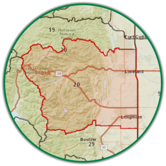
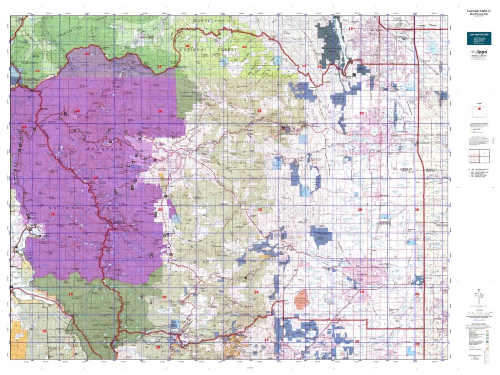
INFO: Mule Deer Hunting in Colorado Unit 20
The higher elevations and steep inclines propel Unit 20 towards the top of the list of more physically demanding units to hunt in Colorado. However, if you are up to the challenge, this unit contains some large mule deer with the average quality measuring between 140” and 160” with the trophy potential of 170” and up. This unit is blanketed with several forested areas that provide substantial cover for the mule deer. However, you as a skilled hunter will know the fresh sign to scout for in order to close in on the deer. Of all the several thousand acres of forested public property in unit 20, Rocky Mountain National Park and Estes Park are off-limits to hunting.

SUCCESS RATES for Mule Deer Hunting in Colorado Unit 20
5 Year Estimated Average for Deer
Archery 16%
Muzzle Loader 20%
2nd Rifle 31%
3rd Rifle 52%
4th Rifle 50%
Mule Deer TROPHY QUALITY for Unit 20 Colorado
Average Quality 140″ – 160″
Trophy Potential 175″+
Buck to Doe Ratio 40:100
Colorado Unit 20 Mule Deer Hunting FORUM Coming Soon!

INFO: Elk Hunting in Colorado Unit 20
Being that Unit 20 sits in the northern boundary of Colorado, it’s no surprise that this area gets cold in the winter. The highest elevations rise in excess of 11,000 feet just north of Rocky Mountain National Park! Therefore, the elk herds will be forced to forage for food further down the mountain. Be mindful of the elk migratory patterns when planning your hunt as the higher mountaintops are more fruitful in the early seasons such as archery, muzzleloader, and first rifle and the lower areas offer more productive hunting in the later rifle seasons. Strategy and persistence pay off BIG since this unit produces trophy elk every passing year!

SUCCESS RATES for Elk Hunting in Colorado Unit 20
5 Year Estimated Average for Elk
Archery 24%
Muzzle Loader 40%
1st Rifle 55%
2nd Rifle 60%
3rd Rifle 52%
4th Rifle 65%
Elk TROPHY QUALITY for Unit 20 Colorado
Average Quality 280″ – 320″
Trophy Potential 330″+
Bull to Cow Ratio 42:100
Colorado Unit 20 Elk Hunting FORUM Coming Soon!

Available Hunts

Unit 20 Hunting Information

lay-of-the-land-icon-.gif

Colorado Unit 20 Topo Map

Total Acreage: 772,000 acres over approximately 1,200 square miles

Total Public Land: 279,000 acres or 36%

Land Ownership Mix: 64% Private; 36% Public; USFS Wilderness: 21,632 acres; USFS: 190,000 acres; BLM: 1,024 acres; State Land: 2,560 acres; Other Govt Owned: 177,152 acres

Species: Black Bear, Elk, Mule Deer, Pronghorn

Elevation Variances: 5,000 ft. to 14,000 ft.

Terrain Difficulty Overall: Mild to Moderate

Land Coverage/Vegetation: 43% evergreen forest, 12% cultivated crops, 12% grassland/herbaceous, 11% shrub/scrub and 4% barren land

Unit 20 Boundaries: (Larimer, Boulder County Colorado) bounded on North by Larimer County Roads 44H (Buckhorn Road), 27, 38E, 19, and Harmony Road; on East by Interstate25; on South by Colorado 52, US-South Highway 287, Boulder County Road 34 (Niwot/Neva Roads), US-South Highway 36, Boulder County Roads 94, 81, 106, and 95 (Left hand Canyon Dr.), 102 (Brainard Lake Road), and ridge line from Brainard Lake West to Pawnee Park; on West by Continental Divide, Rocky Mountain National Park boundary, and Pennock Creek-Elk Creek Divide

map-icon.png

Lay of the Land in CO Unit 20

lay-of-the-land-icon-.gif

Terrain in GMU 20 CO

The mountainous terrain of the west contains steep climbs and rugged landscapes perfect for the adventurous hunter. The eastern grasslands provide big game a false sense of security to graze while your eyes is on them.
vegetation-icon.png

Vegetation in GMU Unit 20 CO

The vegetation in Unit 20 varies depending on the altitude, as would be expected. The higher elevations comprise of the evergreen variety including but not limited to ponderosa pine, spruce, and Douglas firs. The lower elevations are covered with assorted grasses, shrubs, and cacti. The climate is conducive to growing crops that can provide nutrition for the wildlife.
map-directions-icons.png

Access Points in CO GMU 20

]This unit contains several highways and byways including US-34 (East and West),, Denver Boulder Turnpike/Hwy 36 (Northwest and Southeast), CO-7 (North & South). There are 869 miles of trails with 80 trailheads connecting through Unit 20. Be mindful of what areas prohibit vehicles.