New Mexico Unit 2B Hunting Information

Home » Hunting Informations » New Mexico Units Hunting Information » New Mexico Unit 2B Hunting Information

Overview of NM GMU 2B Hunting Facts

Nestled in the northwestern corner of New Mexico in San Juan and Rio Arriba counties, Game Management Unit 2B continues to hold its successful reputation in the hunting game. The warm climate is countered by the abundant water sources, including the Navajo Lake, which is the second largest lake in New Mexico and the San Juan River, which is highly recognized as a place to spot large mule deer and elk. The colder months in Unit 2B are inhabited by migratory herds that have descended from the high altitudes to forage for food. For more New Mexico Unit 2C hunting information, check out the Info for Cities Near Unit 2B section on the right.

Table of Contents

NM Unit 2B Species Hunting Info

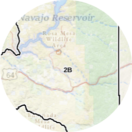
INFO: Mule Deer Hunting in New Mexico Unit 2B

Unit 2B is widely recognized as a trophy mule deer unit and is proven true every year. The unit is managed for population and larger, mature bucks are definitely present. Hike into the remote areas away from the roads to see the most opportunity. The San Juan River bounds this unit on the west and is a prime location for hunting mulies on a large scale! Unit 2B is where high population numbers and record sizes meet!
SUCCESS RATES for Mule Deer Hunting in New Mexico Unit 2B
5 Year Estimated Average for Deer
Archery 10%
Late Archery 42%
Muzzleloader 20%
Rifle 1 40%
Rifle 2 50%
Rifle 3 60%
Archery 1 (YO) 10%
Archery 2 (YO) 40%
Muzzleloader (YO) 25%
Rifle (Youth Only) 45%
Mule Deer TROPHY QUALITY for Unit 2B New Mexico
Average Deer Quality 150″ – 170″
Trophy Deer Potential 180″+
New Mexico Unit 2B Mule Deer Hunting FORUM Coming Soon!]

INFO: Elk Hunting in New Mexico Unit 2B

Although Unit 2B is most accredited for its successful mule deer hunting, the elk herd numbers are making a swift comeback! The warmer temperatures of the unit give hunters a great jumping off point by concentrating their focus on water sources, which is of no shortage in Unit 2B. Hunters find great success glassing the elk herds and stalk big bulls to the finish line.
SUCCESS RATES for Elk Hunting in New Mexico Unit 2B
5 Year Estimated Average for Elk
Archery 1 20%
Archer 2 20%
Muzzleloader 45%
Rifle 50%
Elk TROPHY QUALITY for Unit 2B New Mexico
Average Elk Quality 290″ – 320″
NM Area 2B Trophy Elk Potential 320″+
GMU 2B Bull to Cow Ratio 34:100
New Mexico Unit 2B Elk Hunting FORUM Coming Soon!

INFO: Antelope Hunting in New Mexico Unit 2B

Although the antelope numbers are not the highest as other units in the state, Unit 2B does deliver some good bucks every year. The numerous water sources provide hunters an opportunity to draw the antelope herds to them.
SUCCESS RATES for Antelope Hunting in New Mexico Unit 2B
5 Year Estimated Average for Antelope
Archery 80%
Rifle 75%
Rifle (Youth Only) Unavailable
Antelope TROPHY QUALITY for Unit 2B New Mexico
Average Antelope Size 60″ – 70″
NM Area 2B Trophy Antelope Potential 70″+
New Mexico Unit 2B Antelope Hunting FORUM Coming Soon!

Available Hunts for New Mexico Unit 2B

Unit 2B Hunting Information Video

iconinfo.png

Cities Near NM Unit 2B

lay-of-the-land-icon-.gif

New Mexico Unit 2B Topo Map

Total Acreage: 477,000 acres over 746 square miles

Total Public Land: 406,000 acres or 85%

Land Ownership Mix: 15% Private; 85% Public; US Forest Service: 140,000 acres; BLM: 211,456 acres; State: 30,784 acres; Other Govt Owned: 21,888 acres

Species: Elk, Mule Deer, Pronghorn, Sheep

Elevation Variances: 5,500 ft. to 7,500 ft.

Terrain Difficulty Overall: Mild to Moderate

Land Coverage/Vegetation: 60% shrub/scrub and 30% evergreen forest

NM Unit 2B Boundaries: The portion of Game Management Unit 2 east and north of the following line: From the junction of the NM/CO state line and Pine River, then south along the Pine River to its junction with the San Juan River, then south and west along the San Juan River to its junction with Largo Canyon, then south and east along the central wash of Largo Canyon to its junction with Cereza Canyon, then south and east along the central wash of Cereza Canyon to the Jicarilla Apache Indian Reservation boundary.

map-icon.png

Lay of the Land in NM Unit 2B

lay-of-the-land-icon-.gif

Terrain in GMU 2B NM

The terrain of New Mexico GMU 2B is best summed up as easy to moderate. The foothills contain gradual inclines with rock formations scattered among the scrub cover. The semi-desert terrain of the flatlands offer an ideal area for decoy hunting and glassing from nearby high points. Rivers weave their way through the unit creating a network of streams and creeks, also incorporating the Navajo Reservoir.
vegetation-icon.png

Vegetation in GMU Unit 2B NM

The vegetation of Unit 2B New Mexico varies directly with the elevation and terrain in which it grows. Shrubbery consisting of sagebrush and oak brush, along with pinyon-juniper patches paint the lower to mid-elevation rolling hills as far as the eye can see. Croplands are located throughout the unit, concentrated near water sources. In addition to croplands being located near water sources, riparian vegetation such as cottonwoods, willows and dense grass wetlands occupy the river banks.
map-directions-icons.png

Access Points in NM GMU 2B

NM 527, Hwy 539, NM 173 and Hwy 511 are the main highways that map their way through Unit 2B with Route 64 weaving along the southern border of the unit. Stemming from the main highways are several small gravel roads that help hunters reach the more remote areas. As is the case with any unit in New Mexico, be sure to request a Motor Vehicle Use Map (MVUM) from any Forest Service office or on their website.