New Mexico Unit 55B Hunting Information

Home » Hunting Informations » New Mexico Units Hunting Information » New Mexico Unit 55B Hunting Information

Overview of NM GMU 55B Hunting Facts

Unit 55b is located west of Interstate 25 between Raton and Springer and east of Colfax, Cimarron and Rayado. Elk, mule deer, whitetail deer and pronghorn antelope are hunted on private land, which comprise all but the Maxwell National Wildlife Refuge and a little land around Stubblefield Dam. Check out the Info for Cities Near Unit 55B section on the right.

Table of Contents

NM Unit 55B Species Hunting Info

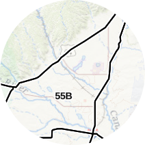
INFO: Mule Deer Hunting in New Mexico Unit 55B
Almost the entire unit is flat to rolling rangeland that provides excellent pronghorn hunting. A few elk and mule deer live along the few brushy creek bottoms where cottonwoods, pinyon pines and junipers grow.

SUCCESS RATES for Mule Deer Hunting in New Mexico Unit 55B
5 Year Estimated Average for Deer
Archery 20.00%
Late Archery 22.00%
Muzzleloader 28.00%
Rifle 1 27.00%
Rifle 2 30.00%
Mule Deer TROPHY QUALITY for Unit 55B New Mexico
Average Deer Quality 140″ – 160″
Trophy Deer Potential 170″+
New Mexico Unit 55B Mule Deer Hunting FORUM Coming Soon!

INFO: Elk Hunting in New Mexico Unit 55B
The first archery season can see extremely high temps. Water is abundant in most of the unit, but stand hunting over wallows can be effective. Hunters with tags for this season should consider hunting during the last part of the season, bugling to locate bulls. The later archery season takes place during the rut. Hunters who hike away from roads often get bulls to respond to bugles and cow calls.

SUCCESS RATES for Elk Hunting in New Mexico Unit 55B
5 Year Estimated Average for Elk
Archery 1 20.00%
Archery 2 28.00%
Rifle 1 50.00%
Rifle 2 35.00%
Rifle 3 20.00%

Elk TROPHY QUALITY for Unit 55B New Mexico
Average Elk Quality 300″ – 330″
NM Area 55B Trophy Elk Potential 340″+

New Mexico Unit 55B Elk Hunting FORUM Coming Soon!

Unit 55B Hunting Information Video

iconinfo.png

Cities Near NM Unit 55A

lay-of-the-land-icon-.gif

New Mexico Unit 55B Topo Map

Total Acreage: 603,000 acres over 942 square miles

Total Public Land: 602,000 acres or 99%

Land Ownership Mix: 1% Private; 99% Public; USFS: 600,128 acres; USFS Wilderness: 524,992 acres; State: 768 acres

Species: Elk, Mule Deer, Sheep, Pronghorn

Elevation Variances: 5,000 ft. to 11,000 ft.

Terrain Difficulty Overall: Mild to Moderate

Land Coverage/Vegetation: 84% evergreen forest and 10% shrub/scrub

Unit 55B Boundaries: The portion of Game Management Unit 55 beginning at the junction of New Mexico Highway 58 and US 64 at Cimarron and running west and south along US 64 to the Colfax-Taos County line at Palo Flechado pass; then north along the Colfax County line to the southern boundary of the Sangre de Cristo Grant; then north and west along the Sangre De Cristo Grant’s southern boundary to NM 522 then north along New Mexico Highway 522 to the Colorado-New Mexico state line; then east along the state line to its intersection with Interstate 25; then south along I-25 to its junction with US 64 then southwest along US 64 to its junction with NM 58 at Cimarron

map-icon.png

Lay of the Land in NM Unit 55B

lay-of-the-land-icon-.gif

Terrain in GMU 55B NM

Except for a couple of tiny mesas and ridges, all the land is flat or barely rising. The Vermejo River cuts through the center, running south of Stubblefield Reservoir and the 3,699-acre Maxwell National Wildlife Refuge. Game and cattle also find water in about 30 other ponds and a handful of other creeks, including the Cimarron River. The vast majority of land is between 6,000 and 6,500 feet above sea level.
vegetation-icon.png

Vegetation in GMU Unit 55B NM

Grasslands occupy almost the entire unit. Trees grow only on tiny Kit Carson Mesa, a few hilly ridges and on the banks of the Cimmaron and Vermejo rivers and along a few creek beds, some of them dry. The trees are mostly cottonwoods, junipers and pinyon pines. Dense tamarisk provides bedding cover along some creeks. Sagebrush and oak brush grow in places, especially along dry and running creeks. The chief grass is grama. A few alfalfa fields and other crop fields are in the southern half of the unit.
map-directions-icons.png

Access Points in NM GMU 55B

Private cattle ranches comprise the whole unit except for the Maxwell refuge, which is closed to hunting, and a strip of Bureau of Reclamation land around Stubblefield Reservoir, which is also inaccessible to hunters.