Colorado unit 16 hunting topo map to plan your successful hunt. Includes private and public land boundaries, roads and topography.
Description
Click Here to View Large Map or to Purchase
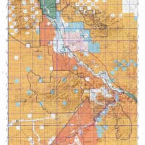
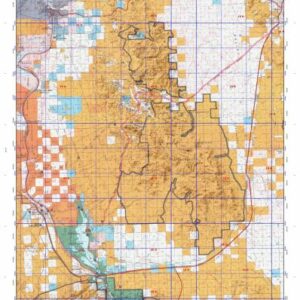
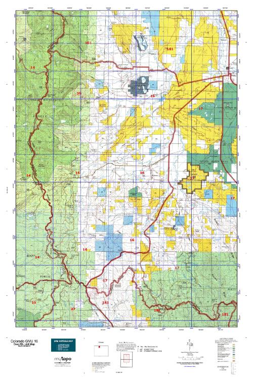
Colorado Unit 16 Hunting Topo Map with Printed Boundaries
Hunters Domain has Colorado Unit 16 hunt area maps that are 1:100,000-scale maps using Bureau of Land Management land status base maps.
Our UNIT 16 maps include:
Colorado public land ownership boundaries
Topographical contour lines
1:100,000 scale for easy viewing
Roads printed
Key terrain features to help you plan your hunt or trip
Hunt area or game management unit 16 (GMU 16) boundary is overlaid on the BLM base map
Easy planning for your upcoming big game hunt by defining roads and routes into the preferred area
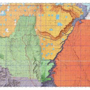
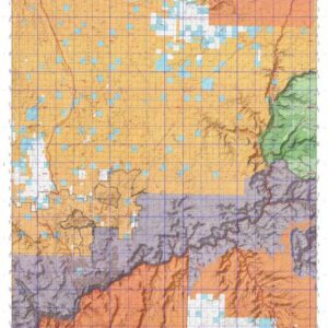
Custom maps for Unit 16 are also available (See it all on one map):
Color aerial photo maps: high resolution (you define borders/boundaries)
TOPO maps only where you easily define borders or edges of maps with our online program
Hybrid maps: a unique and detailed aerial photo combined with a USGS topographical maps (user-defined boundaries)
Order your Colorado Unit 16 Map Today!
The actual boundary description/definitions printed below from Colorado Parks and Wildlife hunting regulations brochure could have errors or been amended by the state so always check in their most current printed regulations or the Colorado Parks and Wildlife website to verify these boundaries before hunting as these are for reference only.
Colorado Big Game Unit 16
– Unit 16 Topo/Map Colorado – Game Management Unit (GMU-16).
Game Management Unit (GMU)
BLM Maps:
Reservation Land
US Forest Service Maps:
Reservation land
Click Here to Order Your Color Colorado Unit 16 Topo Map
Colorado Unit 16 Description
Unit 16 Located in Jackson County bounded on the North by Wyoming; on the East by Jackson-Larimer County line; on the South by Colorado 14; on the West by Colorado 125, from Colorado 14 to Wyoming state line.
GMU 16 North Park borders Wyoming between the Continental Divide and Medicine Bow Mountains. The valley floor at 7,880’ supports agricultural lands and sage. Extensive willow stands line the streams – a favorite moose habitat, so be sure of your target. The forest surrounding the basin varies from aspen/lodgepole to spruce/fir. The area is generally windy and colder than places in western Colorado. Prepare for snow during your hunt. 4WD is helpful, as are chains. Over 2/3 of North Park is public land. Patient hunters could have success hunting trophy bucks. North Park has an early rifle, deer-only season that begins as soon as possible after archery closes. This season provides additional hunter opportunities as many of the deer in North Park migrate early. Few deer are found in North Park during January classification flights. Small sample sizes lead to higher observed buck:doe ratios than can be expected during the hunting seasons. Elk are distributed evenly throughout the unit. During the day, the bulls will be in dark timber – glass in the early morning and evening. The herd tends to stay in the coniferous timbered areas until late in the season, moving to lower elevations with snow and hunting pressure.