Description
Click Here to View Large Map or Order
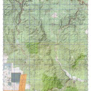
Oregon Unit 73 hunting map topo with printed boundaries
HuntersDomain has Oregon unit 73 hunt area maps that are 1:100,000-scale maps using Bureau of Land Management land status base maps.
Our UNIT 73 maps include:
- Oregon public land ownership boundaries
- Topographical contour lines
- 1:100,000 scale for easy viewing
- Roads printed
- Key terrain features to help you plan your hunt or trip
- Hunt area or game management unit 73 (GMU 73) boundary is overlaid on the BLM base map
- Easy planning for you upcoming big game hunt by defining roads and routes into the preferred area
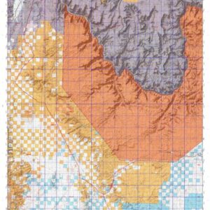
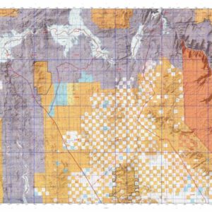
Custom maps for unit 73 are also available (See it all on one map):
- Color aerial photo maps: high resolution (you define borders/boundaries)
- TOPO maps only where you easily define borders or edges of maps with our online program
- Hybrid maps: a unique and detailed aerial photo combined with a USGS topographical maps (user-defined boundaries)
Order your unit 73 Oregon topo map today!
The actual boundary description/definitions printed below from the Oregon Division of Wildlife hunting regulations brochure could have errors or been amended by the state so always check in their most current printed regulations or the Oregon Division of Wildlife website to verify these boundaries before hunting as these are for reference only.
– (Moffat) bounded on N, East, and South by Green River; on West by Utah.
Click Here to Order Unit 73 Topo Map
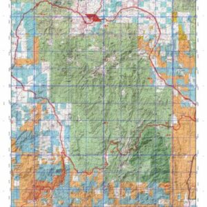
Unit description
WAGONTIRE 85% of public lands. Beginning on United States Highway 20, 2-1/2 mile east of Millican; southeast on Highway 20 to United States Highway 395; southwest on Highway 395 to State Highway 31 at Valley Falls; northwest on Highway 31 to Lk Company Road 5-14F, 9 miles east of Silver Lk; northeast on Lk Company Road 5-14F to Lk Company Road 5-14 at Christmas Valley; east 2 miles on Lk Company Road 5-14 to the junction with Lk Company Road 5-14C, 2 miles east of Christmas Valley; north and northeast on Lk Company Road 5-14C to the junction with Lk Company Road 5-14D; continue north on Lk Company Road 5-14C to the intersection of Lk Company Road 5-12B; west on Lk Company Road 5-12B to Junction of Lk Company Road 5-12D; north on Lk Company Road 5-12D past Janes Well and Dickerson Well to Highway 20, point of beginning. (Maps: Lakeview /Prineville/ Vale Bureau of Land Management)