Description
Click Here to View Large Map or Order
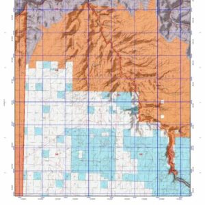
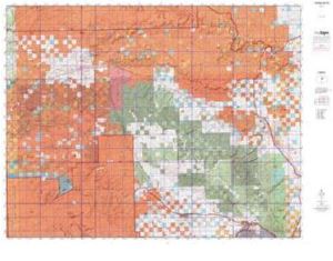
New Mexico Unit 10 hunting map topo with printed boundaries
HuntersDomain has New Mexico unit 10 hunt area maps that are 1:100,000-scale maps using Bureau of Land Management land status base maps.
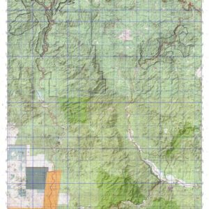
Our UNIT 10 maps include:
- New Mexico public land ownership boundaries
- Topographical contour lines
- 1:100,000 scale for easy viewing
- Roads printed
- Key terrain features to help you plan your hunt or trip
- Hunt area or game management unit 10 (GMU 10) boundary is overlaid on the BLM base map
- Easy planning for your upcoming big game hunt by defining roads and routes into the preferred area
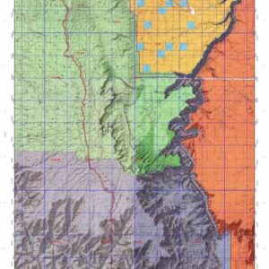
Custom maps for unit 10 are also available (See it all on one map):
- Color aerial photo maps: high resolution (you define borders/boundaries)
- TOPO maps only where you easily define borders or edges of maps with our online program
- Hybrid maps: a unique and detailed aerial photo combined withe USGS topographical maps (user-defined boundaries)
Order your unit 10 New Mexico topo map today!
The actual boundary description/definitions printed below from New Mexico Division of Wildlife hunting regulations brochure could have errors or been amended by the state so always check in their most current printed regulations or the New Mexico Division of Wildlife website to verify these boundaries before hunting as these are for reference only.
– Unit 10 Topo/Map New Mexico – Game Management Unit (GMU-10).
Game Management Unit (GMU) Beginning at the junction of the north boundary of the Zuni Indian Reservation with the New Mexico/AZ state line and running north along the state line to the south boundary of the Navajo Indian Reservation, then east along the south boundary of the Navajo Reservation and north along its east boundary to its intersection with the Standing Rock-Crownpoint road, then southeast along the Standing Rock-Crownpoint road to its junction with New Mexico 371, then east and south along New Mexico 371 to its intersection with the Continental Divide, then east along the Continental Divide to its junction with CR 19 (the road running southerly from Hospah) near Borrego Pass, then south along CR 19 to its junction with Interstate-40 at Prewitt, then southeast along I-40 to its junction with New Mexico 53 near Grants, then south and west along New Mexico 53 to its intersection with the east boundary of the Zuni Reservation, then north along the east boundary of the Zuni Reservation and west along its north boundary to its junction with the New Mexico/AZ state line. Portion of GMU 10: That portion of GMU 10 beginning at the junction of Interstate-40 and New Mexico 400 east of Gallup and continuing south along New Mexico 400 to its junction with the Cibola National Forest boundary; then north along the Cibola National Forest boundary to the Fort Wingate Military Depot boundary, then south and west along the Fort Wingate Military Depot boundary to the Zuni Indian Reservation boundary, then south and east along the Zuni Indian Reservation boundary to its junction with the Rio Nutria, then east along the Rio Nutria to Six Mile Draw, then east and south along Six Mile Draw to its junction with US Forest Service Road 157, then north along USFS 157 to its junction with USFS 459, then east on USFS 459 to its junction with USFS 50, then east and south on USFS 50 to Cottonwood Creek, then north and east along Cottonwood Creek to its junction with the Cibola National Forest boundary, then north and west along the Cibola National Forest boundary to its junction with Interstate-40 at Coolidge, then northwest along Interstate-40 to its junction with New Mexico 400.
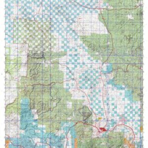
BLM Maps:
.Zuni Quad, Gallup Quad, Grants Quad, and Acoma Pueblo Quad.
US Forest Service Maps:
Cibola National Forest, Mount Taylor District.
Click Here to Order Unit 10 Topo Map